New Role-Based Permissions in SESAR
March 2016
SESAR² Release 6.4 introduced substantial new functionality to support sample metadata access, editing, and registration permissions. The new features enable a SESAR² account owner to give varying levels of permission to others to view, edit, and/or register sample metadata on behalf of the account owner.
These new features were developed in response to user requests to share private metadata with select individuals and to share edit or registration permissions with, for example, a student that may help a SESAR² user manage their samples for a period of time. You can give these privileges to others for an indefinite or set period of time. You can change the level of permissions or remove permission entirely at any point.
There are four levels of permissions that you can give to others for your user codes:
- Read: Give permissions to others to view the metadata for all of your samples under a specific user code, regardless of whether the sample metadata are public or private.
- Read, Edit: In addition to privileges listed in #1, give permissions to others to edit the sample metadata profiles for your samples.
- Read, Edit, Create: In addition to privileges listed in #1 and #2, give permissions to others to register samples under your user code (namespace) through both individual and batch sample registration.
- Read, Edit, Create, Delete: In addition to privileges listed in #1, #2, and #3, give permissions to others to request de-activation of sample metadata profiles. Sample de-activation should be rare, except in the case of an error or a test or duplicate profile.
To share permissions for your user code(s), please be sure that the person you would like to give permissions to has registered for a GeoPass account. Then, please log into MySESAR and click “Set Permission for my User code” under My Account. You will need to know the GeoPass ID (email address) of the person you would like to share permissions with.
If you have questions or comments about the new capabilities or SESAR² in general, please contact info@54.224.199.193.
Smithsonian Registers National Gem, Mineral, and Rock Collections with IGSNs in SESAR²
April 2015
The Smithsonian National Museum of Natural History recently registered nearly 350,000 samples with IGSNs in SESAR², including specimens from the National Gem, National Mineral, and National Rock Collections. The inclusion of these samples in SESAR² greatly enhances the discoverability of these valuable collections*. Furthermore, since data exists for many of these samples in PetDB, the IGSNs can now be added and used to link samples to analyses in different publications regardless of sample naming conventions of individual authors. Click here to view an example sample profile in SESAR², including a link to the Smithsonian Collections web pages. To view all samples, search the catalog for samples beginning with the user code (namespace) ‘NHB’.
These registrations took advantage of the SESAR² Web Services, which are documented here.
*Please note that the use of IGSNs in publications, alone, does not fulfill the Smithsonian loan policy stating that samples must be referenced by museum catalog numbers. Authors should include both museum catalog numbers and IGSNs.
Link your paper with IGSN and make your data more accessible and discoverable
April 2014
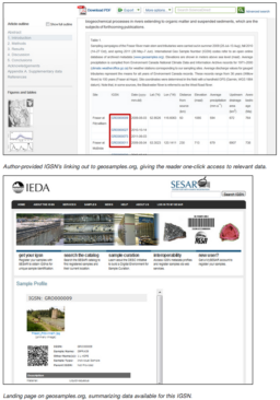
Online papers in Science Direct link directly to sample metadata profiles in SESAR², making all of the metadata about the sample quickly available. When submitting a paper to Elsevier, tables with column headers “IGSN” or text with the prefix “IGSN:” will be identified and linked directly to geosamples.org. For more information please see the International Geo Sample Number section in Elsevier’s Guide for Authors.
See examples:
- Beier et al., 2018, Lithos (Table 1)
- Dere et al., 2013, Geochimica et Cosmochimica Acta (Table 2)
From the Elsevier news item:
We are delighted to highlight the ongoing cooperation with IEDA by announcing the first published papers with linked International Geo Sample Numbers (IGSN). Take a look at Table 2 of this Geochimica et Cosmochimica Acta paper where you can click on specific IGSN numbers and be taken directly to the sample profile held in the SESAR² sample metadata catalog at geosamples.org. By setting up links between databases and published papers, data is more accessible and discoverable, which benefits all researchers in the field.
New linking to the Index to Marine & Lacustrine Geological Samples (IMLGS)
May 2013
SESAR² is working with sample repositories to improve linking between existing sample information. The IMLGS (Index to Marine & Lacustrine Geological Samples) has provided links to their records for over 35,000 SESAR² sample profiles for several sample repositories. The links appear at the bottom of the sample profiles.
Sample repositories with this improved linking include:
- The Antarctic Marine Geology Research Facility (example)
- The Lamont Doherty Core Repository (example)
- The Ocean Drilling Program (example)
- The University of Rhode Island Marine Geological Samples Laboratory (example)
- The Woods Hole Oceanographic Institution (example)
Any user can add relevant URL links to their own profiles by choosing the “edit” link in MySESAR. For bulk updates please contact info@54.224.199.193.
Featured sample collections: The Marine Geoscience Data System (MGDS) sample metadata
November 2012
Sample metadata from the Marine Geoscience Data System (MGDS) have been migrated into SESAR² as part of the consolidation of sample cataloging within the Integrated Earth Data Applications (IEDA) facility. MGDS provides access to data portals for the NSF-supported Ridge 2000 and MARGINS, and GeoPRISMS programs, the Antarctic and Southern Ocean Data Synthesis, and the Academic Seismic Portal. There are over 14,000 sample metadata profiles registered with IGSNs under the user code (namespace) MGD.
Use the SESAR² Catalog Search Advanced Search options to find metadata profiles of specific cruises, platforms or collectors.
Investigators that own the physical samples in the MGD collection are encouraged to register an account with SESAR², which will enable them to organize their samples under their own workspace, edit metadata profiles, and directly register additional sample metadata. Please contact us at info@54.224.199.193 if you would like to transfer your sample metadata from the MGDS ownership into your own account.